I think most folks use the Cispus gage...which most likely doesn't give too great of a comparison but it the best available. On the AW page there's links at the bottom to Cascade Classics trip reports at a variety of levels with photos which gives a nice visual guide.
Also I believe those trip reports referred to the old Cispus near Randle gage which is no longer operating.... and it was downstream of yellowjacket. The current Cispus gage is upstream from Yellowjacket, so it reads lower than the old gage. Good luck.
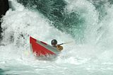
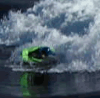
Not sure about rain, but we run McCoy during snowmelt when the Cispus is around 3K. Yellowjacket has a nice medium feel at that level. We figured 700-900 cfs visually at the takeout.
You cannot post new topics in this forum You cannot reply to topics in this forum You cannot delete your posts in this forum You cannot edit your posts in this forum You cannot create polls in this forum You cannot vote in polls in this forum
 Active Topics
 Memberlist
 Search


 IP Logged